Live Traffic Camera: SH-249 @ SH 105 (W2) (North)
Unknown, Texas
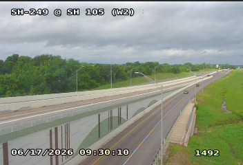
This traffic camera monitors TX-249 in Texas, with a northbound view.
Multiple National Weather Service alerts are active for this camera area. Review the alert details below before traveling through this corridor.
Current weather near this camera is dry, with clear sky and temperatures near 73.3 °F.
The live view is most useful for checking traffic flow, visibility, and any lane restrictions before driving through the Grimes County area.
Additional rain is expected over the next few days, which could keep pavement conditions variable in the Grimes County area.
Camera Information & Location Details
- Highway/Roadway
- TX-249
- Traffic Direction
- North
- County
- Grimes
- City
- Unknown
- Feed Type
- Still Image
- Geographic Coordinates
- 30.35527, -95.97077
- Source Provider
- TxDOT
Real-Time Mapping
Active Weather Alert near this camera
The National Weather Service has issued a weather statement for this camera area.
Tropical Cyclone Statement
Tropical Cyclone Statement issued June 16 at 10:41PM CDT by NWS Houston/Galveston TX
HLSHGX This product covers Southeast Texas **Potential Tropical Cyclone One Expected to Bring Heavy Rainfall to Portions of Southeast Texas** NEW INFORMATION --------------- * CHANGES TO WATCHES AND WARNINGS: - None * CURRENT WATCHES AND WARNINGS: - A Tropical Storm Watch is in effect for Bolivar Peninsula, Brazoria Islands, Chambers, Coastal Brazoria, Coastal Galveston, and Galveston Island * STORM INFORMATION: - About 180 miles southwest of Galveston TX - 27.6N 97.1W - Storm Intensity 30 mph - Movement Northeast or 50 degrees at 6 mph SITUATION OVERVIEW ------------------ Potential Tropical Cyclone One has moved into the western Gulf near Corpus Christi. It is expected to strengthen to a Tropical Depression or weak Tropical Storm as it moves northeastward along the Texas coastline on Wednesday before crossing into southwest Louisiana Wednesday evening. Potential impacts to southeast Texas include the prospect of locally heavy rainfall, 1-3 feet of coastal flooding along the immediate the coast, and gusts to tropical storm force along the immediate coast. A Tropical Storm Watch is currently in effect for all coastal areas of SE Texas and the Gulf waters out 60 nm, with the exception of Matagorda Bay. POTENTIAL IMPACTS ----------------- * FLOODING RAIN: Prepare for life-threatening rainfall flooding having possible extensive impacts across portions of Southeast Texas. Potential impacts include: - Major rainfall flooding may prompt many evacuations and rescues. - Rivers and tributaries may rapidly overflow their banks in multiple places. Small streams, creeks, canals, and ditches may become dangerous rivers. Flood control systems and barriers may become stressed. - Flood waters can enter many structures within multiple communities, some structures becoming uninhabitable or washed away. Many places where flood waters may cover escape routes. Streets and parking lots become rivers of moving water with underpasses submerged. Driving conditions become dangerous. Many road and bridge closures with some weakened or washed out. Prepare for dangerous rainfall flooding having possible limited to significant impacts across northern Brazos Valley and Piney Woods Region. * SURGE: Coastal flood warnings and advisories have been issued for the immediate coast. Please reference the Coastal Hazard Message for more information. Potential impacts in this area include: - Numerous roads may be closed. Low lying property including homes, businesses, and some critical infrastructure could be inundated. Some shoreline erosion will occur. Elsewhere across Southeast Texas, little to no impact is anticipated. * WIND: Little to no significant impacts are anticipated at this time across Southeast Texas. * TORNADOES: Prepare for a tornado event having possible limited impacts across coastal potions of Southeast Texas. Potential impacts include: - The occurrence of isolated tornadoes can hinder the execution of emergency plans during tropical events. - A few places may experience tornado damage, along with power and communications disruptions. - Locations could realize roofs peeled off buildings, chimneys toppled, mobile homes pushed off foundations or overturned, large tree tops and branches snapped off, shallow-rooted trees knocked over, moving vehicles blown off roads, and small boats pulled from moorings. Elsewhere across Southeast Texas, little to no impact is anticipated. PRECAUTIONARY/PREPAREDNESS ACTIONS ---------------------------------- * EVACUATIONS: Follow the advice of local officials. * OTHER PREPAREDNESS INFORMATION: Now is the time to check your emergency plan and emergency supplies kit and take necessary actions to protect your family and secure your home or business. If you live in a place particularly vulnerable to flooding, such as near the ocean or a large inland lake, in a low-lying or poor drainage area, in a valley, or near an already swollen river, plan to move to safe shelter on higher ground. Always heed the advice of local officials and comply with orders that are issued. Do not needlessly jeopardize your life or the lives of others. * ADDITIONAL SOURCES OF INFORMATION: - For information on appropriate preparations see ready.gov - For information on creating an emergency plan see getagameplan.org - For additional disaster preparedness information see redcross.org NEXT UPDATE ----------- The next local statement will be issued by the National Weather Service in Houston/Galveston TX around 4 AM CDT, or sooner if conditions warrant.
- Active until
- 2026-06-17 11:45:00 UTC
- Certainty
- Likely
- Area
- Houston; Trinity; Madison; Walker; San Jacinto; Polk; Burleson; Brazos; Washington; Grimes; Montgomery; Northern Liberty; Colorado; Austin; Waller; Inland Harris; Chambers; Wharton; Fort Bend; Inland Jackson; Inland Matagorda; Inland Brazoria; Inland Galveston; Southern Liberty; Coastal Harris; Coastal Jackson; Coastal Matagorda; Coastal Brazoria; Coastal Galveston; Matagorda Islands; Brazoria Islands; Galveston Island; Bolivar Peninsula
Tropical Cyclone Statement
Tropical Cyclone Statement issued June 17 at 4:40AM CDT by NWS Houston/Galveston TX
HLSHGX This product covers Southeast Texas **Potential Tropical Cyclone One Will Bring Heavy Rainfall to Portions of Southeast Texas** NEW INFORMATION --------------- * CHANGES TO WATCHES AND WARNINGS: - None * CURRENT WATCHES AND WARNINGS: - A Tropical Storm Watch is in effect for Bolivar Peninsula, Brazoria Islands, Chambers, Coastal Brazoria, Coastal Galveston, and Galveston Island * STORM INFORMATION: - About 150 miles southwest of Galveston TX - 28.0N 96.7W - Storm Intensity 30 mph - Movement Northeast or 45 degrees at 6 mph SITUATION OVERVIEW ------------------ Potential Tropical Cyclone 1 will continue to move near the Texas coast today, before crossing into southwest Louisiana this evening. Potential impacts to southeast Texas include the prospect of locally heavy rainfall and flash flooding, 1-3 feet of coastal flooding across the coast and along the bays, and gusts to tropical storm force along the immediate coast. Impacts will persist through today before diminishing this evening as the system lifts to the northeast of the area. A Tropical Storm Watch remains in effect for all coastal areas of SE Texas and the Gulf waters out 60 nm, with the exception of Matagorda Bay. POTENTIAL IMPACTS ----------------- * FLOODING RAIN: Prepare for dangerous rainfall flooding having possible significant impacts across portions of southeast Texas. Potential impacts include: - Moderate rainfall flooding may prompt several evacuations and rescues. - Rivers and tributaries may quickly become swollen with swifter currents and overspill their banks in a few places, especially in usually vulnerable spots. Small streams, creeks, canals, and ditches overflow. - Flood waters can enter some structures or weaken foundations. Several places may experience expanded areas of rapid inundation at underpasses, low-lying spots, and poor drainage areas. Some streets and parking lots take on moving water as storm drains and retention ponds overflow. Driving conditions become hazardous. Some road and bridge closures. Prepare for locally hazardous rainfall flooding having possible limited impacts across the northern Brazos Valley and Piney Woods Region. Elsewhere across Southeast Texas, little to no impact is anticipated. * SURGE: Coastal flood warnings and advisories have been issued for the immediate coast. Please reference the Coastal Hazard Message for more information. Potential impacts in this area include: - Numerous roads may be closed. Low lying property including homes, businesses, and some critical infrastructure could be inundated. Some shoreline erosion will occur. Elsewhere across Southeast Texas, little to no impact is anticipated. * WIND: Little to no significant impacts are anticipated at this time across Southeast Texas. * TORNADOES: Prepare for a tornado event having possible limited impacts across coastal portions of southeast Texas. Potential impacts include: - The occurrence of isolated tornadoes can hinder the execution of emergency plans during tropical events. - A few places may experience tornado damage, along with power and communications disruptions. - Locations could realize roofs peeled off buildings, chimneys toppled, mobile homes pushed off foundations or overturned, large tree tops and branches snapped off, shallow-rooted trees knocked over, moving vehicles blown off roads, and small boats pulled from moorings. Elsewhere across Southeast Texas, little to no impact is anticipated. PRECAUTIONARY/PREPAREDNESS ACTIONS ---------------------------------- * EVACUATIONS: Follow the advice of local officials. * OTHER PREPAREDNESS INFORMATION: If you live in a place particularly vulnerable to flooding, such as near the ocean or a large inland lake, in a low-lying or poor drainage area, in a valley, or near an already swollen river, plan to move to safe shelter on higher ground. Always heed the advice of local officials and comply with orders that are issued. Do not needlessly jeopardize your life or the lives of others. Closely monitor weather.gov, NOAA Weather Radio and local news outlets for official storm information. Listen for possible changes to the forecast. * ADDITIONAL SOURCES OF INFORMATION: - For information on appropriate preparations see ready.gov - For information on creating an emergency plan see getagameplan.org - For additional disaster preparedness information see redcross.org NEXT UPDATE ----------- The next local statement will be issued by the National Weather Service in Houston/Galveston TX around 10 AM CDT, or sooner if conditions warrant.
- Active until
- 2026-06-17 17:45:00 UTC
- Certainty
- Likely
- Area
- Houston; Trinity; Madison; Walker; San Jacinto; Polk; Burleson; Brazos; Washington; Grimes; Montgomery; Northern Liberty; Colorado; Austin; Waller; Inland Harris; Chambers; Wharton; Fort Bend; Inland Jackson; Inland Matagorda; Inland Brazoria; Inland Galveston; Southern Liberty; Coastal Harris; Coastal Jackson; Coastal Matagorda; Coastal Brazoria; Coastal Galveston; Matagorda Islands; Brazoria Islands; Galveston Island; Bolivar Peninsula
Current Weather near traffic camera in Unknown, Texas
Clear sky
- Temperature
- 73.3 °F
- Feels Like
- 79.6 °F
- Humidity
- 95%
- Wind
- 6.3 mph
- Wind Direction
- ESE (107°)
- Precipitation
- 0.00 inch
Forecast
- Max
- 89.9 °F
- Min
- 72.6 °F
- Precip.
- 0.02 inch
- Status
- Slight rain
- Max
- 94.2 °F
- Min
- 75.8 °F
- Precip.
- 0.00 inch
- Status
- Clear sky
- Max
- 93.3 °F
- Min
- 78.0 °F
- Precip.
- 0.02 inch
- Status
- Slight rain
Observed at: 2026-06-17 10:00 UTC (weather data updated hourly)
Nearby Cameras
SH-249 @ SH 105 (W)
Unknown
TX-249
Direction: North
Distance: 0.0 miles
SH-249 @ SH 105
Unknown
TX-249
Direction: North
Distance: 0.3 miles
SH-249 @ FM 1748 (N)
Unknown
TX-249
Direction: North
Distance: 0.3 miles
SH-249 @ Co 412 (S)
Unknown
TX-249
Direction: North
Distance: 0.4 miles
SH-249 @ FM 1748
Unknown
TX-249
Direction: North
Distance: 0.7 miles
SH-249 @ Co 306 (N)
Unknown
TX-249
Direction: North
Distance: 1.3 miles
SH-249 @ Co 306
Unknown
TX-249
Direction: North
Distance: 1.7 miles
SH-249 @ Co 307 (N)
Unknown
TX-249
Direction: North
Distance: 2.2 miles
SH-249 @ Co 307
Unknown
TX-249
Direction: North
Distance: 2.5 miles