Live Traffic Camera: SH-6 @ FM2004 (North)
Hitchcock, Texas
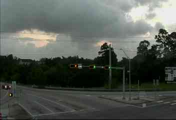
This traffic camera monitors TX-6 in Hitchcock, Texas, with a northbound view.
A National Weather Service warning is active for this camera area. Review the alert details below before traveling, especially if conditions on the live view change quickly.
Current weather near this camera is dry, with clear sky and temperatures near 85.9 °F.
The live view is most useful for checking traffic flow, visibility, and any lane restrictions before driving through the Hitchcock area.
Additional rain is expected over the next few days, which could keep pavement conditions variable in the Hitchcock area.
Camera Information & Location Details
- Highway/Roadway
- TX-6
- Traffic Direction
- North
- County
- Galveston
- City
- Hitchcock
- Feed Type
- Still Image
- Geographic Coordinates
- 29.35263, -95.03075
- Source Provider
- TxDOT
Real-Time Mapping
Active Weather Alert near this camera
Hazardous weather is occurring or expected soon near this camera area.
Tropical Storm Warning
Tropical Storm Warning issued June 17 at 11:38AM CDT by NWS Houston/Galveston TX
A Tropical Storm Warning means tropical storm-force winds are expected somewhere within this area within the next 36 hours * LOCATIONS AFFECTED - Dickinson - Eastern League City - Texas City * WIND - LATEST LOCAL FORECAST: Tropical storm force winds remain possible - Peak Wind Forecast: 10-20 mph with gusts to 25 mph - THREAT TO LIFE AND PROPERTY THAT INCLUDES TYPICAL FORECAST UNCERTAINTY IN TRACK, SIZE AND INTENSITY: Wind less than 39 mph - The wind threat has remained nearly steady from the previous assessment. - PLAN: The sustained wind should remain less than tropical storm force. Conditions may still be gusty. - PREPARE: Listen for any instructions from local officials. - ACT: Ensure emergency readiness should the forecast change. - REALIZED IMPACTS: Being Assessed - Little to no additional wind impacts expected. Community officials are now assessing the extent of actual wind impacts accordingly. * STORM SURGE - LATEST LOCAL FORECAST: Localized storm surge possible - Peak Storm Surge Inundation: The potential for 1-3 feet above ground somewhere within surge prone areas - Window of concern: Begins this morning - THREAT TO LIFE AND PROPERTY THAT INCLUDES TYPICAL FORECAST UNCERTAINTY IN TRACK, SIZE AND INTENSITY: Potential for storm surge flooding greater than 1 foot above ground - The storm surge threat has remained nearly steady from the previous assessment. - PLAN: Plan for storm surge flooding greater than 1 foot above ground. - PREPARE: Efforts should now be underway to prepare for storm surge flooding, especially in low-lying vulnerable areas. - ACT: Take actions to protect life and property. Prepare to leave if evacuation orders are given for your area. - POTENTIAL IMPACTS: Limited - Localized inundation with storm surge flooding mainly along immediate shorelines and in low-lying spots, or in areas farther inland near where higher surge waters move ashore. - Sections of near-shore roads and parking lots become overspread with surge water. Driving conditions dangerous in places where surge water covers the road. - Moderate beach erosion. Heavy surf also breaching dunes, mainly in usually vulnerable locations. Strong rip currents. - Minor to locally moderate damage to marinas, docks, boardwalks, and piers. A few small craft broken away from moorings. * FLOODING RAIN - LATEST LOCAL FORECAST: Flood Watch is in effect - Peak Rainfall Amounts: No additional significant rainfall forecast - THREAT TO LIFE AND PROPERTY THAT INCLUDES TYPICAL FORECAST UNCERTAINTY IN TRACK, SIZE AND INTENSITY: Potential for moderate flooding rain - The flooding rain threat has remained nearly steady from the previous assessment. - PLAN: Emergency plans should include the potential for moderate flooding from heavy rain. Evacuations and rescues are possible. - PREPARE: Consider protective actions if you are in an area vulnerable to flooding. - ACT: Heed any flood watches and warnings. Failure to take action may result in serious injury or loss of life. - POTENTIAL IMPACTS: Significant - Moderate rainfall flooding may prompt several evacuations and rescues. - Rivers and tributaries may quickly become swollen with swifter currents and overspill their banks in a few places, especially in usually vulnerable spots. Small streams, creeks, canals, and ditches overflow. - Flood waters can enter some structures or weaken foundations. Several places may experience expanded areas of rapid inundation at underpasses, low-lying spots, and poor drainage areas. Some streets and parking lots take on moving water as storm drains and retention ponds overflow. Driving conditions become hazardous. Some road and bridge closures. * TORNADO - LATEST LOCAL FORECAST: - Situation is somewhat favorable for tornadoes - THREAT TO LIFE AND PROPERTY THAT INCLUDES TYPICAL FORECAST UNCERTAINTY IN TRACK, SIZE AND INTENSITY: Potential for a few tornadoes - The tornado threat has remained nearly steady from the previous assessment. - PLAN: Plans should still include the potential for a few tornadoes. - PREPARE: Keep informed should additional weather alerts be needed. - ACT: If a tornado warning is issued, be ready to shelter quickly. - POTENTIAL IMPACTS: Limited - The occurrence of isolated tornadoes can hinder the execution of emergency plans during tropical events. - A few places may experience tornado damage, along with power and communications disruptions. - Locations could realize roofs peeled off buildings, chimneys toppled, mobile homes pushed off foundations or overturned, large tree tops and branches snapped off, shallow-rooted trees knocked over, moving vehicles blown off roads, and small boats pulled from moorings. * FOR MORE INFORMATION: - Hurricane Preparedness: Federal Emergency Management Agency - http://ready.gov/hurricanes - Local weather conditions and forecasts: NWS Houston/Galveston, TX - http://www.weather.gov/hgx/
- Active until
- 2026-06-18 00:45:00 UTC
- Certainty
- Likely
- Area
- Coastal Galveston
Current Weather near traffic camera in Hitchcock, Texas
Clear sky
- Temperature
- 85.9 °F
- Feels Like
- 93.4 °F
- Humidity
- 74%
- Wind
- 10.4 mph
- Wind Direction
- S (173°)
- Precipitation
- 0.00 inch
Forecast
- Max
- 86.6 °F
- Min
- 77.3 °F
- Precip.
- 0.93 inch
- Status
- Heavy rain
- Max
- 88.2 °F
- Min
- 78.9 °F
- Precip.
- 0.09 inch
- Status
- Slight rain
- Max
- 89.0 °F
- Min
- 80.5 °F
- Precip.
- 0.00 inch
- Status
- Clear sky
Observed at: 2026-06-17 20:00 UTC (weather data updated hourly)
Nearby Cameras
SH-146 @ FM1765
Texas City
TX-146
Direction: North
Distance: 5.1 miles
IH-45 Gulf @ Scarsdale
Houston
I-45
Direction: South
Distance: 19.7 miles
S Sam Hou BW 8 @ Beamer (W)
Houston
Direction: West
Distance: 21.2 miles
S Sam Hou BW 8 @ SH 35
Houston
TX-35
Direction: West
Distance: 23.0 miles
SH99 @ Cedar Bayou
Unknown
TX-99
Direction: East
Distance: 26.0 miles
SH99 @ W Bay Rd
Unknown
TX-99
Direction: East
Distance: 26.5 miles
SH99 @ FM 1405
Unknown
TX-99
Direction: East
Distance: 27.1 miles
SH99 @ Cedar Port Pkwy
Unknown
TX-99
Direction: East
Distance: 27.8 miles
SH99 @ FM 1405 (E)
Unknown
TX-99
Direction: East
Distance: 27.8 miles