Live Traffic Camera: LP-1 @ Enfield Rd (North)
Austin, Texas
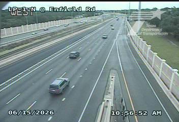
This traffic camera monitors LP-1 in Austin, Texas, with a northbound view.
Multiple National Weather Service alerts are active for this camera area. Review the alert details below before traveling through this corridor.
Light rain is reported near this camera, with temperatures near 74.2 °F. Allow extra braking distance and watch for spray from nearby traffic.
Additional rain is expected over the next few days, which could keep pavement conditions variable in the Austin area.
Camera Information & Location Details
- Highway/Roadway
- LP-1
- Traffic Direction
- North
- County
- Travis
- City
- Austin
- Feed Type
- Still Image
- Geographic Coordinates
- 30.28641, -97.76319
- Source Provider
- TxDOT
Real-Time Mapping
Active Weather Alert near this camera
Hazardous weather is occurring or expected soon near this camera area.
Flash Flood Warning
Flash Flood Warning issued June 15 at 5:27AM CDT until June 15 at 8:00AM CDT by NWS Austin/San Antonio TX
FFWEWX The National Weather Service in Austin/San Antonio has extended the * Flash Flood Warning for... Northern Blanco County in south central Texas... Northeastern Hays County in south central Texas... Southern Travis County in south central Texas... * Until 800 AM CDT. * At 527 AM CDT, Doppler radar and automated rain gauges indicated thunderstorms producing heavy rain across the warned area. Between 2 and 4 inches of rain have fallen. Additional rainfall amounts up to 1 inch are possible in the warned area. Flash flooding is ongoing or expected to begin shortly. HAZARD...Life threatening flash flooding. Thunderstorms producing flash flooding. SOURCE...Radar and automated gauges. IMPACT...Life threatening flash flooding of creeks and streams, urban areas, highways, streets and underpasses. * Some locations that will experience flash flooding include... Austin, Buda, Dripping Springs, Round Mountain, Tanglewood Forest, Austin Bergstrom Int Airport, Lakeway, Bee Cave, West Lake Hills, The Hills, Johnson City, Rollingwood, Mustang Ridge, Niederwald, Bear Creek, Barton Creek, Pedernales Falls State Park, Shady Hollow, Cypress Mill and Onion Creek.
Turn around, don't drown when encountering flooded roads. Most flood deaths occur in vehicles. Be especially cautious at night when it is harder to recognize the dangers of flooding. Be aware of your surroundings and do not drive on flooded roads.
- Active until
- 2026-06-15 13:00:00 UTC
- Certainty
- Likely
- Area
- Blanco, TX; Hays, TX; Travis, TX
Flood Watch
Flood Watch issued June 14 at 9:31PM CDT until June 16 at 7:00PM CDT by NWS Austin/San Antonio TX
* WHAT...Flooding caused by excessive rainfall continues to be possible. * WHERE...A portion of south central Texas, including the following counties, Atascosa, Bandera, Bastrop, Bexar, Blanco, Burnet, Caldwell, Comal, De Witt, Dimmit, Edwards, Fayette, Frio, Gillespie, Gonzales, Guadalupe, Hays, Karnes, Kendall, Kerr, Kinney, Lavaca, Lee, Llano, Maverick, Medina, Real, Travis, Uvalde, Val Verde, Williamson, Wilson and Zavala. * WHEN...Through Tuesday evening. * IMPACTS...There is a potential for life threatening flooding somewhere in the watch area. Excessive runoff may result in flooding of rivers, creeks, streams, and other low-lying and flood-prone locations. Creeks and streams may rise out of their banks. Low-water crossings may be flooded. * ADDITIONAL DETAILS... - Very humid tropical air and a stalling front will result in heavy rain. Isolated pockets with rain totals of 8 inches or more are possible with rain rates that could exceed 2 to 3 inches per hour at times. - http://www.weather.gov/safety/flood
You should monitor later forecasts and be alert for possible Flood Warnings. Those living in areas prone to flooding should be prepared to take action should flooding develop.
- Active until
- 2026-06-17 00:00:00 UTC
- Certainty
- Possible
- Area
- Llano; Burnet; Williamson; Val Verde; Edwards; Real; Kerr; Bandera; Gillespie; Kendall; Blanco; Hays; Travis; Bastrop; Lee; Kinney; Uvalde; Medina; Bexar; Comal; Guadalupe; Caldwell; Fayette; Maverick; Zavala; Frio; Atascosa; Wilson; Karnes; Gonzales; De Witt; Lavaca; Dimmit
Current Weather near traffic camera in Austin, Texas
Rain: Slight
- Temperature
- 74.2 °F
- Feels Like
- 82.1 °F
- Humidity
- 97%
- Wind
- 4.7 mph
- Wind Direction
- E (85°)
- Precipitation
- 0.03 inch
Forecast
- Max
- 87.5 °F
- Min
- 73.8 °F
- Precip.
- 4.65 inch
- Status
- Heavy rain
- Max
- 83.8 °F
- Min
- 72.6 °F
- Precip.
- 0.09 inch
- Status
- Slight rain
- Max
- 85.0 °F
- Min
- 72.9 °F
- Precip.
- 0.00 inch
- Status
- Clear sky
Observed at: 2026-06-15 10:00 UTC (weather data updated hourly)
Nearby Cameras
LP-1 @ Windsor Rd
Austin
LP-1
Direction: North
Distance: 0.4 miles
LP-1 @ Highgrove Terr
Austin
LP-1
Direction: North
Distance: 0.5 miles
LP-1 @ Bowman Ave
Austin
LP-1
Direction: North
Distance: 0.7 miles
LP-1 @ 5th Street
Austin
LP-1
Direction: North
Distance: 0.8 miles
LP-1 @ Veterans Dr
Austin
LP-1
Direction: North
Distance: 0.9 miles
LP-1 @ Oakmont Blvd
Austin
LP-1
Direction: North
Distance: 1.2 miles
LP-1 @ Colorado River
Austin
LP-1
Direction: North
Distance: 1.2 miles
LP-1 @ Barton Springs Blvd
Austin
LP-1
Direction: North
Distance: 1.4 miles
LP-1 @ 35th Street
Austin
LP-1
Direction: North
Distance: 1.6 miles