Live Traffic Camera: Shasta River Bridge (N/A)
Weed, California
All cameras on I-5 in California →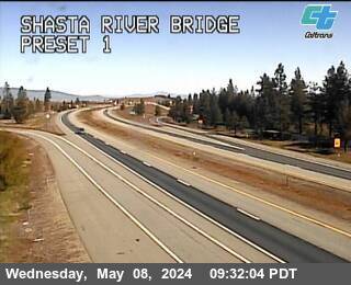
This traffic camera monitors I-5 in Weed, California.
Current weather near this camera is dry, with clear sky and temperatures near 63.6 °F.
The live view is most useful for checking traffic flow, visibility, and any lane restrictions before driving through the Weed area.
Additional rain is expected over the next few days, which could keep pavement conditions variable in the Weed area.
Camera Information & Location Details
- Highway/Roadway
- I-5
- Traffic Direction
- N/A
- County
- Siskiyou
- City
- Weed
- Feed Type
- Still Image
- Geographic Coordinates
- 41.43889, -122.43281
- Source Provider
- Caltrans
Real-Time Mapping
Current Weather near traffic camera in Weed, California
Clear sky
- Temperature
- 63.6 °F
- Feels Like
- 55.1 °F
- Humidity
- 25%
- Wind
- 9.4 mph
- Wind Direction
- N (359°)
- Precipitation
- 0.00 inch
Forecast
- Max
- 63.6 °F
- Min
- 30.6 °F
- Precip.
- 0.00 inch
- Status
- Clear sky
- Max
- 61.1 °F
- Min
- 42.0 °F
- Precip.
- 0.03 inch
- Status
- Slight rain
- Max
- 66.5 °F
- Min
- 40.0 °F
- Precip.
- 0.03 inch
- Status
- Slight rain
Observed at: 2026-06-07 00:00 UTC (weather data updated hourly)
Nearby Cameras
North Weed
Weed
I-5
Distance: 1.8 miles
Weed Airport
Weed
I-5
Distance: 2.7 miles
I5-US97
Weed
I-5
Distance: 2.7 miles
South Weed
Weed
I-5
Distance: 3.5 miles
Summit Dr
Mount Shasta
I-5
Distance: 5.4 miles
Black Butte
Mount Shasta
I-5
Distance: 7.1 miles
Abrams Lake NB
Mount Shasta
I-5
Distance: 8.0 miles
Central Mt Shasta
Mt Shasta
I-5
Direction: North
Distance: 10.7 miles
I5-SR89
Mount Shasta
I-5
Distance: 12.6 miles